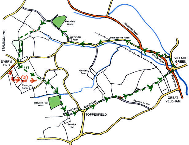
Circular walk, about 3 hours, can be muddy in parts. Just over 7 miles.
There is one stile to climb, and one flight of steps to the High Street (which can be avoided).
There is one stile to climb, and one flight of steps to the High Street (which can be avoided).
Go along North Road towards Tilbury juxta Clare.
Turn left into Duncan Rise, then go slightly right, at the end of the road go left up hill along the footpath with St. Andrew's School on your right.
At Church Road go right.
either, 1, if you have the consent of the landowner at Great Yeldham Hall to use the private part of old railway line, cross the road before Mann's Cross and follow the
footpath between two gardens, over a concrete bridge and over a meadow to the old railway line and go right to the Stambourne Road,
or 2, go left along the Stambourne Road.
Follow the Stambourne Road past the turning to Gunce's Farm on the left, go right just past the side of Weybridge Farm, where the buildings are used to pack Basmati Rice.
Follow the hard track up the hill with Weybridge Farm to your right, then with farm land on each side. Pass Pettyfield Wood on your right, ignoring the footpath joining from the right on the near side the wood, and then ignoring the by-way joining from the right on the far side of the wood.
Go left from the track at a way-marking post in a gap in the hedge and into a field.
Go down the side of the field with the hedge on your right.
At the bottom of the field go right across the footbridge a little way ahead in the next field and left across another footbridge. Once over the bridge keep ahead with the hedge on your left.
Leave the field at the far side through a gap and turn left. This soon becomes a grassy farm track past the end of a narrow meadow. Go right over the stile into the meadow.
Go diagonally across the meadow down towards the opposite far side. Go through a gate (narrow people go round its end).
Go along the bottom of the meadow with the hedge and a pill box on your right (the official route goes the other side of the sewage works through a very narrow and apparently unused path), to the end, cross the stile to the road in Dyer's End. (The stile is in such poor condition that it would be reasonable to use the metal gate at the cattle grid).
Either: 1, go along the Yeldham Road a short way to the last house entrance on the right before the first field. Cross diagonally left over a short piece of lawn, pass through a gap in the conifer hedge and go up the middle of the field to the lane at the far end.
or 2, go along the Finchingfield Road, to a gap in the houses on the left with a concrete footpath sign beside 'Charisma',
and go left. Go ahead up the hill with a paddock fence
on your left.
Cross a wooden bridge into a small field and go diagonally left across that field to another bridge in a gap in the hedge at the far opposite corner to a
much larger field. (Note: the OS maps may show field boundaries since removed.)
Carry on across the field to the top of the far side where there is a gap to a lane.
Cross the road by the way marking post. Go ahead down a field through a short length of cultivated land to join the field boundary in the same direction. Continue in the same line down the hill with the ditch on your left. Cross a narrow meadow with the ditch still on your left.
Go ahead up the opposite side of the valley with Berwick Hall Wood on your right towards the farm buildings at the top of the slope. This is very heavy clay soil and can be very difficult walking when wet until you reach the concrete farm road.
Follow the concrete farm road to the top of the hill then go left round the yard on a permissive diversion. Go left along the track which becomes Park Lane leading into Toppesfield.
In Toppesfield go right past Chapel House on your right to the main road junction. Go left along Church Lane, past the Green Man Public House.
Ignore footpaths joining on the left from Gunce's Farm and continue along Church Lane into where it becomes a green lane, where you see a gap on your left go left and then right into a field. This is Kitley Field, Great Yeldham Hall. Follow the field margin with the hedge and ditch on your right.
At the corner cross a plank bridge into Brickyard Field, Great Yeldham Hall. Go left and along the field boundary with the hedge on your left. Ignore the path joining from the left from the landing strip.
At the end of the field ignore the path from the sports ground on the right, continue along a narrow uncultivated strip across a field to a gap in the hedge.
Go ahead, ignore the unofficial path joining from along the old railway track on the right. Continue with a field on the left and houses on the right.
Join Great Yeldham High Street from down the concrete steps beside the Police Station. (To avoid the steps go through the gap on the right side to Whitlock Drive, down onto the High Street, left, then right to the Village Green.)
Cross the road to return to the village green.
4 Apr 2013