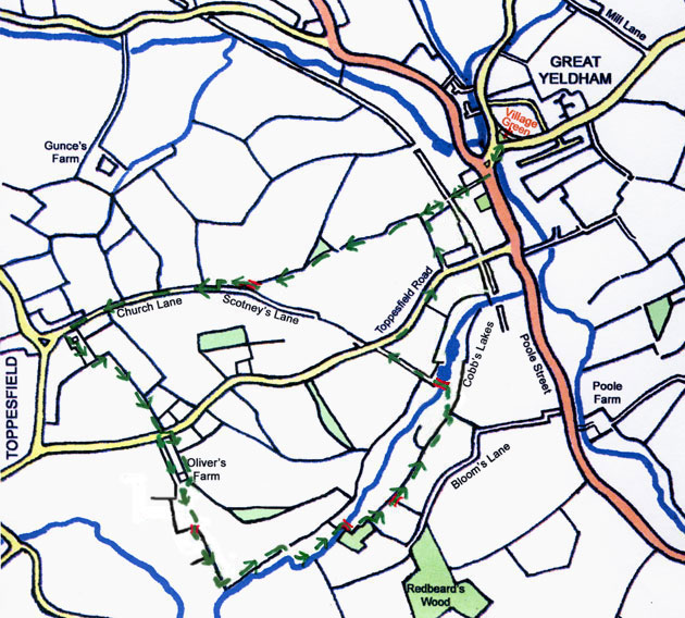
Go down Bridge Street, over the bridge, go left of the small triangular green to the High Street.
Just opposite to the Police Station cross the main road.
Go up the concrete steps just to the left of the old Police Station, follow the path behind the houses. (To avoid the steps go to the top right side of Whitlock Drive, and go through the gap on the right).
At the end of the houses ignore the junction with a path along the old railway line on the left and go foreward along a narrow uncultivated strip across a field. This is Smiths Field, Great Yeldham Hall.
At the far side of the field ignore the junction with the path on the left which leads to the Sports Ground, go foreward with the hedge and ditch on your right.
This is Brickyard Field, Great Yeldham Hall.
Continue to the far side of the field ignoring a path joining from the right which leads to the landing strip.
At the far end of the field go right over a plank bridge.
Go left with the hedge and ditch to your left along the side of Kitley Wood Field.
At a gap in the hedge on the left, go left then go right along a green lane which becomes Church Lane, Toppesfield.
Ignore paths joining from Gunce's Farm on the right.
Go left into Toppesfield Churchyard, past the Church on your left and out through a gap at the far end.
Go left into the field and follow the boundary right at the corner and down to the road with the hedge on your left.
The definitive path through Oliver's Farm is obstructed. Mostly walkers go right along the road a short distance and then left along the drive and down the hill at Oliver's Farm. (Previously walkers went left for a few yards along the road, crossed over and through a gap by a footpath signpost. Following the path into a field with the fence of Oliver's Farm on their right.)
We hope that either the official right of way is reinstated or that the usual unofficial diversion is formally accepted.
Go through a gap just to the left of the corner and down and up the sides of an unbridged ditch. You emerge in a small patch of nettles. Go a short distance along an old concrete road and go over a field diagonally left down across the cultivated land. The path is usually cut or sprayed off. Join the unmade farm road and continue down the hill to the corner of the hedge on your right. Cross over a footbridge to continue down hill along the far side of the hedge.
At the bottom go left through the gap and follow the path with the river on your right. Go right through a broad gap into a long narrow water meadow. Go left at the first corner and along the length of the meadow, pass through a gap into another narrow meadow and go right over a wooden footbridge. Go ahead to the near corner and left beside a wood. At the far end of the wood go right though a field entrance and left along the top of a filled-in ditch with the bank on your left.
Continue along the bottom of this and the next field. At the far end the path becomes enclosed by a fence on your right and a hedge on the left.
Go left through a gap in the hedge and down into a Willow plantation. Go right to follow the same hedge in the same direction but on the lower side then go diagonally left down the slope to the wooden footbridge.
After heavy rain the ground can be covered with water over a six inches deep.
Cross the wooden footbridge and go ahead through a thicket to a large fishing lake. Taking care not to disturb fishermen, go left round the end of the lake. As you emerge from the thicket surrounding the lake go up the green lane ahead to the Toppesfield Road.
Turn right at Toppesfield Road and continue towards Great Yeldham, turn left into a side road leading into the Sports Ground. Follow the footpath along the boundary of the Sports Ground, behind the Pavillion and Scout Hut, leaving by a gap in the hedge. Go ahead, then turn right where you join the path from Toppesfield. Cross the field and the old railway track and continue with a field on the left and houses on the right.
Join Great Yeldham High Street from down the concrete steps beside the Police Station. (To avoid the steps go through the gap on the right side to Whitlock Drive, down onto the High Street, left, then right to the Village Green.)
Cross the road to return to the village green.
11 May 2013